

 View Advisory HERE
AIR QUALITY ALERT IN EFFECT TO 11 PM TONIGHT & HEAT ADVISORY REMAINS IN EFFECT TO 8PM TONIGHT
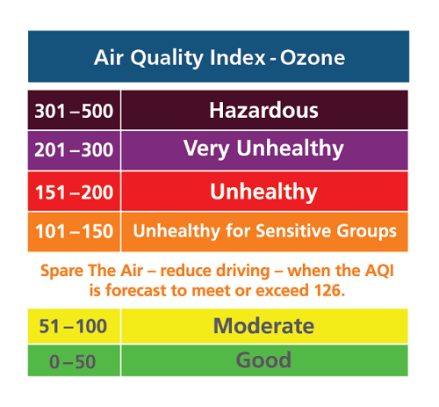
The Massachusetts Department of Environmental Protection has issued an Air Quality Action Day for Ground Level Ozone, in effect until 11 PM tonight! An Air Quality Action day means that Ground Level Ozone concentrations within the region may approach or exceed unhealthy standards.View Advisories HERE


AIR QUALITY ALERT IN EFFECT FROM 11 AM TO 11 PM EDT TUESDAY…
The Massachusetts Department of Environmental Protection has issued an Air Quality Action Day for Ground Level Ozone, in effect from 11 AM to 11 PM EDT Tuesday July 10, 2018
An Air Quality Action day means that Ground Level Ozone concentrations within the region may approach or exceed unhealthy standards
Current Air Quality Report & Forecast HERE
MassDEP Air & Climate HERE

…WINTER WEATHER ADVISORY WEDNESDAY 3/21/18 5pm THROUGH THURSDAY 3/22/18 MORNING…
* WHAT… Wet snow. Total snow accumulations will range from 3 to 5 inches on the upper Cape, Martha`s Vineyard, and Block Island, to as little as 1 to 2 inches on the outer Cape.
* WINDS…Northeast 20 to 30 mph with gusts up to 60 mph with the strongest winds Wednesday night into Thursday morning.
* WHERE…Cape Cod and the Islands.
* WHEN…From Wednesday morning through Thursday morning.
* ADDITIONAL DETAILS…Plan on difficult travel conditions. Tree branches could fall. Significant reductions in visibility are possible.
VIEW FORECAST HERE

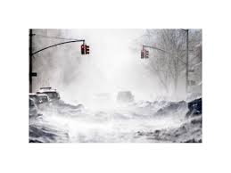 …BLIZZARD WARNING IN EFFECT FROM 11 PM THIS EVENING TO 8 PM EDT TUESDAY…
* WHAT…Blizzard conditions expected. Winds gusting as high as 65
mph will cause whiteout conditions in blowing snow. Significant
drifting of the snow is likely. Total snow accumulations of 10
to 18 inches with localized 20 inch amounts possible.
* WHERE…Coastal Essex County, Plymouth County, Cape Cod and
Marthas Vineyard.
* WHEN…From 11 PM this evening to 8 PM EDT Tuesday.
* ADDITIONAL DETAILS…Travel will be very dangerous with 1 to 3
inch per hour snowfall rates at times and significantly impact
the morning commute. The Tuesday afternoon commute is also
expected to be impacted. Wet snow and strong winds will result
in some power outages and tree damage.


…HIGH WIND WARNING IN EFFECT FROM 1 PM WEDNESDAY TO 1 AM THURSDAY…
The National Weather Service in Taunton has issued a High Wind
Warning, which is in effect from 1 PM Wednesday, March 7 to 1 AM Thursday, March 8.
* Location…Eastern Massachusetts from Plymouth County to Cape
Cod and the Islands.
* Winds…East 20 to 30 mph with gusts up to 60 mph.
* Timing…Strongest winds Wednesday afternoon and evening.
* Impacts…Damage to trees, power lines, and property are
possible with winds of this magnitude. Power outages are likely.
PRECAUTIONARY/PREPAREDNESS ACTIONS…
A High Wind Warning is issued when sustained winds of 40 mph are
expected for at least one hour, with gusts of 58 mph or greater
at any time. Take action to secure loose outdoor objects.

…WINTER WEATHER ADVISORY IN EFFECT FROM 7 PM THIS EVENING TO 7 AM EST SUNDAY…
* WHAT…Snow expected. Plan on difficult travel conditions. Total
average snow accumulations of 2 to 4 inches are expected.
Locally higher amounts up to 7 inches possible across the upper
Cape.
* WHERE…Barnstable County.
* WHEN…From 7 PM this evening to 7 AM EST Sunday.
* ADDITIONAL DETAILS…Be prepared for reduced visibilities at
times. Untreated surfaces will be slippery.
PRECAUTIONARY/PREPAREDNESS ACTIONS…
A Winter Weather Advisory for snow means periods of snow will
cause primarily travel difficulties. Be prepared for snow covered
roads and limited visibilities, and use caution while driving.
Weather Forecast Here


You must be logged in to post a comment.