
Chief Contract Negotiating Committee Meeting
Monday January 31, 5:30pm, Freedom Hall
View Agenda HERE

Chief Contract Negotiating Committee Meeting
Monday January 31, 5:30pm, Freedom Hall
View Agenda HERE
View Legally Posted Agendas HERE
Town Council Meeting – Thursday February 3, 7pm, Remote
Cotuit Fire Commission Negotiating Committee- Friday February 4, 5:30pm, Freedom Hall Executive Session Cancelled
Cotuit Fire Commission – Tuesday February 8, 5:30pm, Remote
Precinct 7 Monthly Open Meeting – Wednesday February 9, 3-4:30pm, Cotuit Library
Town Council Appointments Committee – Tuesday February 15, 5pm, Remote
Cotuit Fire District By-Laws Committee – Tuesday February 15, 6pm, Remote
Cotuit Water Commission – Wednesday February 16, 5:30pm, Remote
Town Council Meeting – Thursday February 17, 7pm, Remote
Cotuit Fire Commission Negotiating Committee- Friday February 18, 6pm, Freedom Hall Executive Session
Cotuit Fire Commission – Thursday February 24, 6pm, Remote
Cotuit Fire District Cotuit School Sub Committee – Thursday February 24, 7pm, Remote
Cotuit Prudential Committee – Monday February 28, 6pm, Remote

Report a power outage online or call 800-592-2000 Sign-up to receive outage and restoration updates via text, email or phone. By signing up to receive text updates, you’ll also be able to report an outage by text message and receive on-demand updates.
View Eversource Power Outage Map – HERE
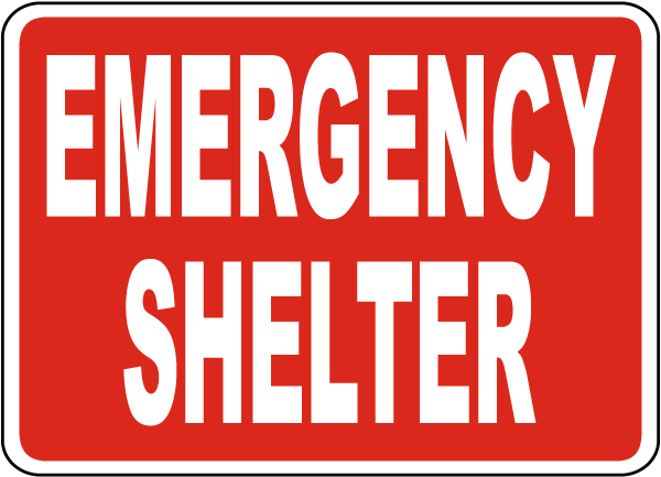
(3) Emergency Shelters are Open
All citizens seeking shelter at one of the open regional shelters, please exercise extreme caution while road conditions remain hazardous. Members of the public are advised to shelter in place, if able, until the wind and snow ease in the late afternoon/evening.
Shelters are staffed by 24 AmeriCorps Cape Cod Members, Members of Regional CERT Teams, and the Cape Cod Medical Reserve Corps. All three locations have emergency food available, provided by the Salvation Army.
The remaining shelters at Dennis-Yarmouth High School, Cape Cod Regional Technical High School, and Nantucket High School are on standby. Check OPEN/CLOSED status of shelters at https://www.bcrepc.org/
The BCREPC wants to emphasize that during shelter operation, COVID-19 remains a significant concern. Residents and visitors should reach out to family and friends first and access shelters only when other options are not available. Likewise, the public is asked to check on neighbors, relatives, and friends who may need assistance.
Masks are required at emergency shelters. People are encouraged to bring their own, but masks will also be available for anyone who needs them.
The Tribal Headquarters in Mashpee will be open for Mashpee Wampanoag Tribe Members to shelter.
Anyone who must utilize a shelter should bring at least three days of essentials, including all medications.
Shelters can accommodate people who use an oxygen breathing apparatus.
Those bringing infants or toddlers to the shelters should also bring formula, food, diapers, wipes, changes of clothing, toys, and a “pack ‘n play” or portable crib and bedding.
Pets are accepted at all regional shelters. Please bring all your pet supplies to the shelter except for crates, which are provided by the shelter. You cannot sleep with your pet(s).
PUBLIC URGED TO STAY INDOORS AND STAY OFF ROADS
View Snow Plow Tracker HERE
WINTER STORM UPDATE | Monday, January 31, 2022 | 11:30 AM
DPW is organizing snow removal operations for this Tuesday night into early Wednesday morning. The locations for snow removal are the “business” districts of Main Street Hyannis, Main Street Osterville and Main Street Barnstable Village. Due to the amount of snow that fell, we will begin snow removal operations at 10:00 PM on Tuesday night (2/1/22) and our expectation is to complete the effort by 7:00 AM on Wednesday morning (2/2/22).
WINTER STORM UPDATE | Sunday, January 30, 2022 | 10:30 AM
Good Morning, we are back and resuming efforts. The plan for the day is to continue the work in secondary roads, and work to improve some of our Main roads. Plow drivers will be out across town, so please be aware that they will be on the roads and stay out of their way when possible.
Please note we did not send this message out at 2:00 AM so as not to disturb your sleep.
WINTER STORM UPDATE | Sunday, January 30, 2022 | 2:00 AM
We are breaking for the night and sending crews home to sleep. The main roads are in decent shape. Most secondary roads have been opened, with a few exceptions that require special equipment. Crews will return at 10AM this morning to continue working on the secondary roads.
WINTER STORM UPDATE | Saturday, January 29, 2022 | 8:00 PM
Good Evening, it has been a difficult afternoon. The heavy bands of snow that came through later in the afternoon set all the roads considerably back. Additionally, the whiteout conditions made it almost impossible for the plow drivers to see, and at one point we had to cease plowing operations all together. We have now resumed and are heading back onto all roads. The plan for this evening is to try and get all roads open and passable for emergency service vehicles. At that point we will need to break and let crews sleep, returning in the morning to start the cleanup process.
WINTER STORM UPDATE #5 | Saturday, January 29, 2022 | 4:00 PM
Conditions are still difficult with the combination of drifting and blowing snow. There are a number of trees and limbs down and associated wires. Forecast is calling for the storm to remain intense during the afternoon. The heaviest snowfall is expected to end this evening with light to moderate snow persisting until midnight. There is a possibility of coastal flooding with the evening high tide. Please stay off of the roads if possible.
WINTER STORM UPDATE | Saturday, January 29, 2022 | 11:30 AM
Conditions are still difficult, with significant winds and blowing snow. Forecast is calling for the storm to intensify during the afternoon, and then begin to diminish this evening. There are a number of trees and limbs down and associated wires. Please continue to stay off the roads if possible.
WINTER STORM UPDATE | Saturday, January 29, 2022 | 7:30 AM
Since the last update the winds have picked up. We are seeing sustained winds in the 25-35 MPH range, and gusts into the high 40 MPH. Some tree damage is already being reported. Visibility is dropping, with heavy wet snow continuing to fall. Snowfall rates are predicted to continue to increase and reach greater than an inch an hour from 9AM until 3PM. This will make very difficult plowing and driving conditions. Please stay off the roads if possible.
WINTER STORM UPDATE | Saturday, January 29, 2022 | 5:30 AM
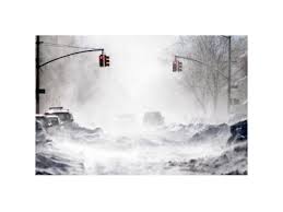
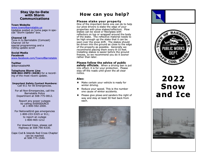
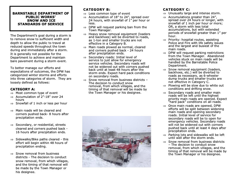
Good Morning, Winter Storm Kenan is upon us. The DPW began plowing main roads at 1AM this morning and at 5AM began plowing secondary roads. Latest forecasts indicate that there will be significant snowfall today, often at rates greater than an inch an hour. Winds are predicted to be 60-75 MPH so white out conditions with extensive drifting is expected. These conditions will be very challenging for the DPW, and it is very possible we are looking at a Category C storm (please refer to the Town’s 2022 Snow and Ice Brochure). As a result the Town has issued a parking ban on all main streets. If at all possible, please stay off the roads.
Due to the storm, the Transfer Station at 45 Flint Street, Marstons Mills, will be closed today, January 29, 2022.

Issued by National Weather Service
Boston, MA
3:37 AM EST Sat, Jan 29, 2022
…BLIZZARD WARNING REMAINS IN EFFECT UNTIL 5 AM EST SUNDAY…
* WHAT…Blizzard conditions expected. Total snow accumulations of 18 to 24 inches with localized 30 inches possible. Winds gusting as high as 70 mph.
* WHERE…Portions of eastern, northeastern and southeastern Massachusetts.
* WHEN…From midnight tonight to 5 AM EST Sunday.
* IMPACTS…Travel could be extremely difficult to impossible. Very strong winds could cause extensive tree damage.
* ADDITIONAL DETAILS…Considerable blowing and drifting snow along with near white out conditions at times. Snowfall rates of 2 to 4 inches per hour is possible at times.
PRECAUTIONARY/PREPAREDNESS ACTIONS…
Travel should be restricted to emergencies only. If you must travel, have a winter survival kit with you. If you get stranded, stay with your vehicle.
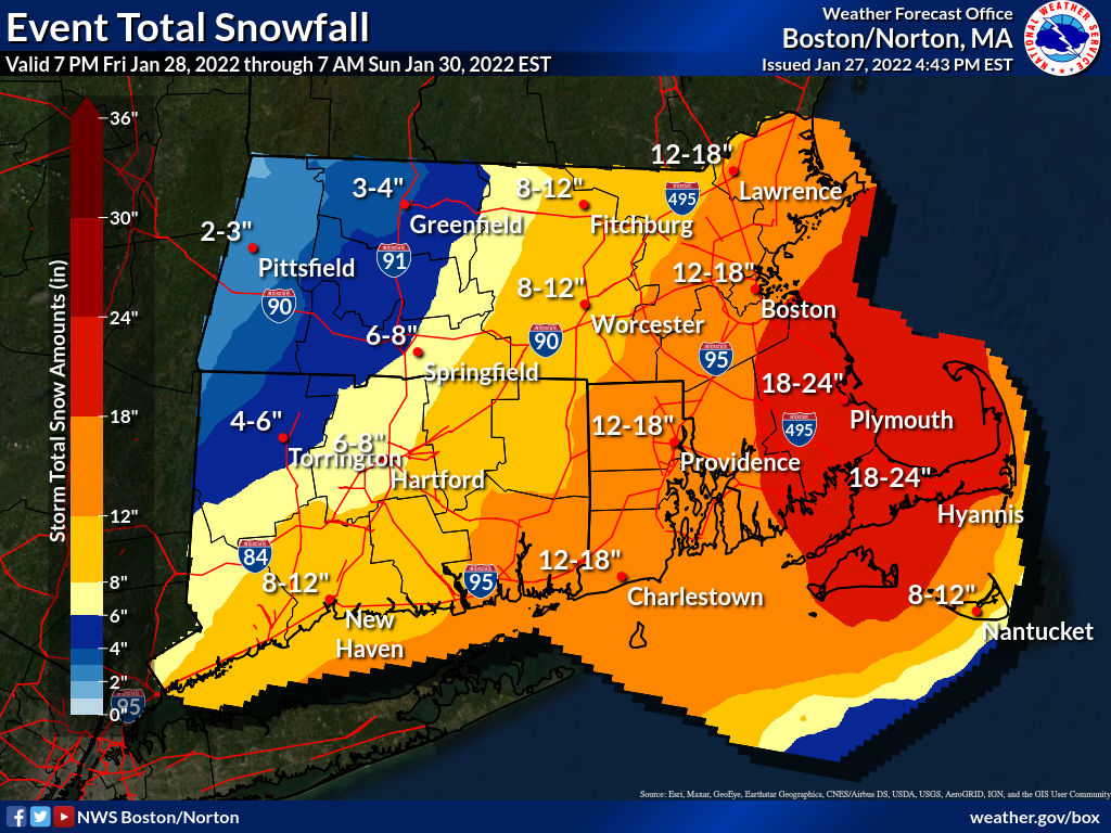
URGENT - WINTER WEATHER MESSAGE
National Weather Service Boston/Norton MA
320 PM EST Thu Jan 27 2022

MAZ017>023-280430-
/O.CON.KBOX.WS.A.0005.220129T0500Z-220130T0500Z/
Northern Bristol MA-Western Plymouth MA-Eastern Plymouth MA-
Southern Bristol MA-Southern Plymouth MA-Barnstable MA-Dukes MA-
Including the cities of Taunton, Brockton, Plymouth, Fall River,
New Bedford, Mattapoisett, Chatham, Falmouth, Provincetown,
and Vineyard Haven
320 PM EST Thu Jan 27 2022

...WINTER STORM WATCH REMAINS IN EFFECT FROM LATE FRIDAY NIGHT
THROUGH SATURDAY EVENING...

* WHAT...Heavy snow possible. Total snow accumulations of 15 to
  22 inches possible. Winds could gust as high as 65 mph.

* WHERE...Portions of southeastern Massachusetts.

* WHEN...From late Friday night through Saturday evening.

* IMPACTS...Travel could be very difficult to impossible. Strong
  winds could cause tree damage.
VIEW FORECAST HERE
Current 2021 Shellfish Permits Expire March 1, 2022

To obtain or renew a Recreational Shellfish Permit View HERE


Cotuit Fire District Prudential Committee
Monday January 24, 6pm, Remote
View Agenda HERE
Link: Join Zoom Meeting
https://us02web.zoom.us/j/3462071880
Meeting ID: 346 207 1880 or phone 646 558 8656
This is a reminder that all abatement applications for FY22 Real Estate and Personal Property taxes must be postmarked or clocked into the Assessor’s office by February 1, 2022 at 4:30 PM; otherwise, the Board of Assessors has no legal authority to consider your application. FedEx, UPS or other delivery service date stamps are not legal postmarks by state law. Abatement applications mailed to the Collector’s office with tax bill payments that do not reach the Assessor’s office by the deadline date and time are also late and cannot be legally considered by the Board of Assessors. The Board of Assessors has no discretion to consider an abatement that is not legally filed.
(a) Unless your property has data errors that have resulted in a higher value than it should have, the evidence on abatement applications must be in the form of sales of similar properties in a similar location; or, if you own an income-producing property, in the form of 3 complete years of your actual income and expense data showing a net operating income result each year, without taking out depreciation, debt service or taxes. The sales must also come from the same time period that the assessing department had to use to establish the values. For FY22, sales from 1/1/2020 through 12/31/2020 were used to set values for single family homes & condominiums. Commercial, industrial, & vacant land sales were taken from 1/1/2019 through 12/31/2020 due to the low number of sales in 2020. Sales outside of those dates are not allowed as abatement evidence since the assessor did not have those sales to use to set the FY22 values. A minimum of 3 similar property sales is best. Your chosen sales should support the total taxable value (land & improvements) of your property. Once you have chosen your sales, you must also submit your opinion of value that you wish the Board of Assessors to consider. If no opinion of value is included, or is not supported by sales, it is almost certain you will receive a denial because once assessments are approved by the Department of Revenue each year, they are legally deemed correct and all the burden of proof otherwise is on the taxpayer.
b) The Board of Assessors has 3 months from the date you submit your abatement application to make a determination. If you feel you have additional evidence that was not included with your original abatement filing for some reason, you may request in writing to attend the Board Meeting where your abatement is scheduled to be heard, however, a personal appearance before the Board to rehash evidence already submitted seldom results in a different decision. The Board will allow 10-15 minutes per taxpayer to present additional evidence but they will not render a decision to you at the meeting. Notice of the decision will be sent like all other abatement requests. Once they’ve decided, the assessing staff has 10 days from the date of the decision to mail a notice of their decision to the taxpayer.
c) If you feel you have not gotten a fair review of your property’s value by the Board of Assessors, you may further appeal the valuation to the Appellate Tax Board (ATB), which requires a filing fee. The instructions for filing such an appeal will be outlined on the certificate form mailed to you after the Board’s decision is made. All hearings with the ATB take place at 100 Commonwealth Avenue in Boston and usually will take approximately a year to be scheduled from your application. The same type of evidence that the Board of Assessors requires will also be required for the ATB’s consideration.

The Town of Barnstable is updating its Local Comprehensive Plan (LCP). The LCP will set out a vision for growth and development, land use, infrastructure, and resource protection for this distinctive community and its seven villages, as well as a targeted action plan to guide the Town’s future work and resource allocation.
The LCP’s development will be steered by a Local Comprehensive Planning Committee (LCPC). The purpose of the Committee is to better facilitate and communicate the planning process, and engage the greater community in the planning effort.
The Town is seeking volunteer members for this important committee.
Selected members will be asked to participate in a two-phase process that will take place over the next two years, with regular meetings (virtual and/or in-person) with the Committee and the community. A committee member should expect to commit to a minimum of monthly evening meetings during that time. The Committee will be responsible for establishing the planning process, including the public engagement plan, and developing and recommending a draft Local Comprehensive Plan to the Town Council. The Committee will be supported by Town staff and an outside planning consultant, as directed by the Town Manager.
Please complete the application online at the Barnstable Local Comprehensive Plan website HERE and email it to BarnstableLCP@town.barnstable.ma.us; or print and return to the Town Manager’s Office at 367 Main Street, Hyannis by the end of business on February 21, 2022.
Applications can also be found at each of the seven village libraries, the Hyannis Youth and Community Center, and the Barnstable Adult Community Center.
The Committee shall be constituted and appointed by the Town Manager. Due to the importance and far-reaching impacts of the work to be undertaken by the Committee, the Town Manager will request that all appointments to the Committee be ratified by the Town Council.
The following will be considered when selecting appointees:
Should representatives from any of the above-stated Boards/Committees/Commissions not be identified, consideration shall be given to appointing residents (in addition to No. 1 above) with subject matter expertise in a similar field.
Please direct questions to BarnstableLCP@town.barnstable.ma.us with LCP Committee in the subject line.
Fire Commission Meeting
Tuesday January 18, 2022 5:30pm, Freedom Hall & Remote
View Agenda HERE
Link: Join Zoom Meeting
https://us02web.zoom.us/j/3462071880
Meeting ID: 346 207 1880
Or Dial+1 646 558 8656

View Transcript of Speech he delivered on August 28, 1968 HERE
Monday January 24, 2022 9 am – 2:30 pm
Cotuit Federated Church, 40 School St., Cotuit
Check and request timed appointment HERE
Thank you!


URGENT - WEATHER MESSAGE
National Weather Service Boston/Norton MA
354 PM EST Sun Jan 16 2022

MAZ007-015-016-019-022>024-171000-
/O.CON.KBOX.HW.W.0002.220117T0600Z-220117T1700Z/
Eastern Essex MA-Suffolk MA-Eastern Norfolk MA-
Eastern Plymouth MA-Barnstable MA-Dukes MA-Nantucket MA-
Including the cities of Gloucester, Boston, Quincy, Plymouth,
Chatham, Falmouth, Provincetown, Vineyard Haven, and Nantucket
354 PM EST Sun Jan 16 2022

...HIGH WIND WARNING REMAINS IN EFFECT FROM 1 AM TO NOON EST
MONDAY...

* WHAT...Southeast winds 30 to 40 mph with gusts up to 65 mph
  expected. Highest winds from outer Cape Cod to Cape Ann.

* WHERE...Eastern Essex MA, Suffolk MA, Eastern Norfolk MA,
  Eastern Plymouth MA, Barnstable MA, Dukes MA and Nantucket MA
  Counties.

* WHEN...From 1 AM to noon EST Monday.

* IMPACTS...Damaging winds will blow down tree limbs and power
  lines. Power outages are possible. Travel will be difficult,
  especially for high profile vehicles.

PRECAUTIONARY/PREPAREDNESS ACTIONS...

People should avoid being outside in forested areas and around
trees and branches. If possible, remain in the lower levels of
your home during the windstorm, and avoid windows. Use caution if
you must drive.
URGENT - WEATHER MESSAGE
National Weather Service Boston/Norton MA
258 AM EST Fri Jan 14 2022

MAZ022>024-142100-
/O.CON.KBOX.HW.W.0001.220114T1600Z-220115T1000Z/
Barnstable MA-Dukes MA-Nantucket MA-
Including the cities of Chatham, Falmouth, Provincetown,
Vineyard Haven, and Nantucket
258 AM EST Fri Jan 14 2022

...HIGH WIND WARNING REMAINS IN EFFECT FROM 11 AM THIS MORNING TO
5 AM EST SATURDAY...

* WHAT...North winds 40 to 50 mph with gusts up to 70 mph
  expected.

* WHERE...Dukes MA, Nantucket MA and Barnstable MA Counties.

* WHEN...From 11 AM this morning to 5 AM EST Saturday.

* IMPACTS...Damaging winds will blow down trees and power lines.
  Widespread power outages are expected. Travel will be
  difficult, especially for high profile vehicles.

PRECAUTIONARY/PREPAREDNESS ACTIONS...

People should avoid being outside in forested areas and around
trees and branches. If possible, remain in the lower levels of
your home during the windstorm, and avoid windows. Use caution if
you must drive.
Open Burning Season begins January 15 – May 1 between the hours of 10-4. Permits are not required however you must call the Cotuit Fire Department (508)428-2210 after 9:30am on the morning you wish to burn.

MassDEP answers to your burning questions HERE

Transfer Station Hours of Operation
Monday, January 17, 2022
The Town of Barnstable Department of Public Works Solid Waste Division will be closed Monday, January 17, 2022 in observance of Martin Luther King Jr. Day. Trash and recycling services will resume on a normal schedule Tuesday, January 18, 2022.
For questions, call P.J. Kelliher at 508-420-2258.
Transfer Station & Recycling Division Information HERE
Wednesday January 12, 2022, 4pm
Special School Committee Meeting – Discuss Three Candidates and Vote for One
View Meeting HERE
Monday, January 10, 2022
Superintendent Candidate Interviews – Open Public Meeting
Barnstable Adult Community Center
825 Falmouth Road, Hyannis (Route 28) – next to Barnstable Intermediate School.
Interviews begin at 4:00 p.m. and are scheduled to last no longer than an hour.
June Saba-Maguire (Brockton Public Schools)
Scott Carpenter (Monomoy Regional)
Sara Ahern (Franklin Public Schools)
Remote Access to the Superintendent Interviews:
YouTube
Or on Comcast Channel 22
The School Committee meets at 4 p.m. this Wednesday at the Town Hall to discuss candidates and make a selection.
Board of Water Commissioners
Wednesday January 12, 2022, 5:30pm, Remote
View Agenda HERE
Zoom: Meeting ID: 346 207 1880
Cotuit Library – 871 Main Street


URGENT - WINTER WEATHER MESSAGE
National Weather Service Boston/Norton MA
1032 PM EST Thu Jan 6 2022

MAZ022-071145-
/O.CON.KBOX.WS.W.0002.220107T0600Z-220107T2100Z/
Barnstable MA-
Including the cities of Chatham, Falmouth, and Provincetown
1032 PM EST Thu Jan 6 2022

...WINTER STORM WARNING REMAINS IN EFFECT UNTIL 4 PM EST FRIDAY...

* WHAT...Heavy snow expected. Total snow accumulations of 1 to 7
  inches. Winds gusting as high as 40 mph.

* WHERE...Barnstable MA County.

* WHEN...Until 4 PM EST Friday.

* IMPACTS...Travel could be very difficult. The hazardous
  conditions could impact the morning commute.

PRECAUTIONARY/PREPAREDNESS ACTIONS...

If you must travel, keep an extra flashlight, food, and water in
your vehicle in case of an emergency.

The latest road conditions for the state you are calling from can
be obtained by calling 5 1 1.
URGENT - WINTER WEATHER MESSAGE
National Weather Service Boston/Norton MA
222 PM EST Thu Jan 6 2022

MAZ022-070900-
/O.UPG.KBOX.WS.A.0003.220107T0600Z-220108T0000Z/
/O.EXB.KBOX.WS.W.0002.220107T0600Z-220107T2100Z/
Barnstable MA-
Including the cities of Chatham, Falmouth, and Provincetown
222 PM EST Thu Jan 6 2022

...WINTER STORM WARNING IN EFFECT FROM 1 AM TO 4 PM EST FRIDAY...

* WHAT...Heavy snow expected. Total snow accumulations of 2 to 7
  inches, heaviest near the Cape Cod Canal.

* WHERE...Barnstable MA County.

* WHEN...From 1 AM to 4 PM EST Friday.

* IMPACTS...Travel could be very difficult. The hazardous
  conditions will impact the morning or evening commute.

* ADDITIONAL DETAILS...Snowfall rates up to 1 inch per hour are
  possible Friday morning. The snow may briefly mix with rain on
  the outer Cape around Chatham to Wellfleet which will result in
  lower accumulations here.

PRECAUTIONARY/PREPAREDNESS ACTIONS...

If you must travel, keep an extra flashlight, food, and water in
your vehicle in case of an emergency.
View Forecast HERE

Cotuit Fire District By-Laws Committee Meeting
Wednesday January 5, 2022, 6pm, Freedom Hall & Remote
View Agenda HERE
Link: Join Zoom Meeting
https://us02web.zoom.us/j/3462071880
Meeting ID: 346 207 1880 or phone 646 558 8656


You must be logged in to post a comment.