Fireworks July 3, 2022, 9pm Cotuit Inner Harbor
hosted by the Oyster Harbors Club


Fireworks July 3, 2022, 9pm Cotuit Inner Harbor
hosted by the Oyster Harbors Club

Cotuit Fire District Prudential Committee
Monday June 27, 6pm, Remote
View Agenda HERE
Link: Join Zoom Meeting
https://us02web.zoom.us/j/3462071880
Meeting ID: 346 207 1880 or phone 646 558 8656
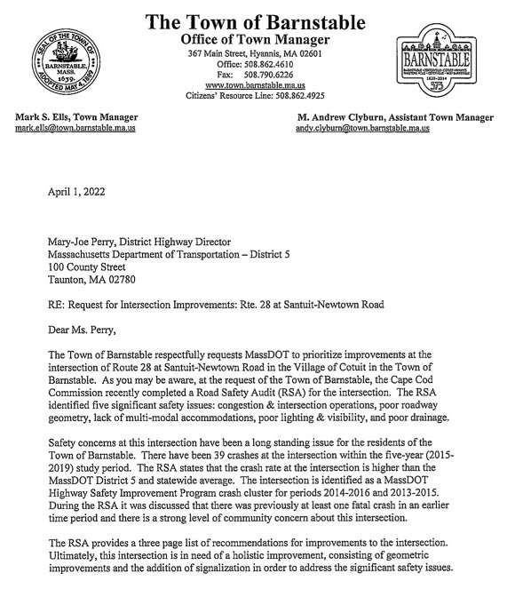
Update: 6/21/22
Copy of letter sent to Mark Ells by MassDOT
“Mark S. Ells
Town Manager Town of Barnstable 367 Main St. Hyannis, MA 02601
June 14, 2022
Subject: MassDOT Highway Division Project 612776 BARNSTABLE – INTERSECTION IMPROVEMENTS AT ROUTE 28 (FALMOUTH ROAD) AND SANTUIT-NEWTOWN ROAD- Project Eligibility Notification
Dear Mr. Ells:Please be advised that the Highway Division’s Project Review Committee (PRC) has approved a project in the Town of BARNSTABLE – INTERSECTION IMPROVEMENTS AT ROUTE 28 (FALMOUTH ROAD) AND SANTUIT-NEWTOWN ROAD and assigned it the project number 612776. MassDOT will now begin the project development process for this project. As the project develops, MassDOT will coordinate with the town to determine priorities and potential phasing depending on the availability of funds.
PRC approval is not a commitment of state or federal funding to the project. MassDOT, in conjunction with the Cape Cod Commission, continually evaluates transportation needs and priorities. MassDOT is responsible for the design, permitting, and documentation required to complete the project through construction.
District 5 will keep you informed of the project’s progress and will involve you in any key decisions related to the project scope, any right-of-way impacts, possible environmental concerns, traffic management plans, or anything else warranted.
You may monitor this project’s progress through the MassDOT web site at
https://hwy.massdot.state.ma.us/projectinfo/projectinfo.asp
District 5, 1000 County Street, Taunton, MA 02780 Tel: 857-368-5000, Fax: 508-880-6102 http://www.mass.gov/massdot”
Update: 6/1/22
Sharing the good news that MassDOT approved a new project for Route 28 at Santuit Newtown Road earlier this month at their PRC meeting. MassDOT initiated an intersection improvement project for this intersection at the Project Review Committee (PRC) meeting held on May 12, 2022. This is the first step necessary for a project to develop through the TIP process for design and construction. The project was approved through PRC. The design process can now begin.
MassDOT looks forward to working with the Town as this project progresses!
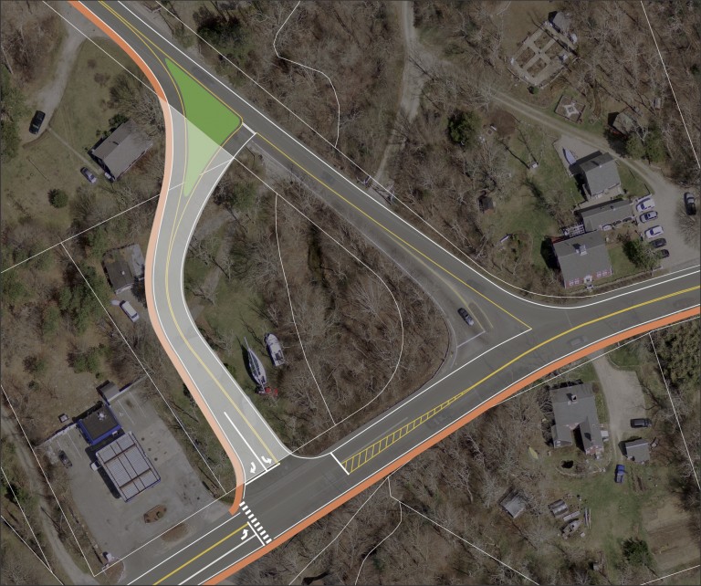

Update: 4/1/22
Update: 3/2/2022
View Final Route 28 at Santuit-Newtown Road Safety Audit HERE
JUST INFORMED THIS IS NOT A PUBLIC MEETING!
Virtual Road Safety Audit (RSA) on Thursday, December 9, 2021 from 1:00 PM to 4:00 PM for the intersection of Route 28 at Santuit-Newtown Road.
UPDATE: 11/23/21
Road Safety Audit Review Prompt List
The Safety Review Prompt List provides basic safety-related questions to use when evaluating a given roadway location. The prompt list should be considered when evaluating a roadway to design improve- ments or conduct a Road Safety Audit. The primary purpose of the prompt list is to identify potential road safety hazards. The list is meant to be general and should be used to prompt an evaluator as to specific matters identified in the field that may have an adverse effect on road safety. The Safety Review Prompt List is not a check of compliance with design standards.
This Prompt List represents the minimum that should be considered when exploring safety opportunities and is not intended to address all aspects of safety.
A summary of the responses should be prepared to highlight potential safety improvement opportunities.
Speed
Are posted speed limits consistent with speed regulations; are they adequate?
Are design features consistent with the posted speed (passing opportunities, sight distance,
warning signs for horizontal and vertical curves, clearance intervals, sign placement, etc.) Are adequate controls in place for driver compliance with speed limits?
Multi-modal
Have accommodations been provided for safe movement of pedestrians, bicycles, emergency vehicles, public transportation, and commercial vehicles?
What design features could be improved, added, or removed to enhance the safe mobility of the various modes?
Pavement Markings
Are there highly visible and retro reflective edge lines, center lines, and other pavement markings?
Do the pavement markings provide sufficient guidance to the road users? Can the placement of the pavement markings be modified to improve guidance to road users?
Signs
Are all signs retro reflective and visible for all roadway conditions, including placed free from obstructions?
Are signs located to maximize perception and reaction while minimizing intrusion in clear zones? Does the signage provide adequate guidance to road users for given road conditions?
Are pavement markings and signs consistent in effectively guiding road users?
Intersection Control
Do all signs (stop signs, lane assignments, street names, etc.) provide visible, clear, non-conflicting messages?
Is there clear, non-conflicting visibility of traffic control (signal heads, signs, and markings) from all approach lanes?
Has the potential of misrepresentation of intersection control been considered (at closely spaced intersections or through control that is against expectation)?
For signalized intersections, have the implications on safety been considered for the signal phasing?
Is there a safe means by which all modes can travel through the intersection? Lighting
Is lighting (from headlights and/or streetlights) adequate for specific roadway conditions and/or use?
If glare exists from sunlight or opposing headlights, are there countermeasures that can be implemented to minimize potentially detrimental effects?
Obstructions
Are there obstructions to sight lines or roadway guidance (signs, markings, etc.) that can be removed, relocated, or minimized as part of this project?
If obstructions or fixed objects exist but cannot be moved, can they be shielded (with guardrails, etc.) or delineated (with reflectors) to improve road user safety? If so, what can be done?
Pavement
Could the condition of the pavement impact mobility and safety (potholes, edge drop-offs, skid resistance, etc.)?
What improvements can be made to minimize safety impacts?
Access Points and Traffic Generators
Is the access control sufficient for the road’s function?
Are site access points located to maximize safety while still providing adequate access?
Have impacts of site developments been adequately accommodated for safe mobility of all
road users?
Parking
Is parking clearly delineated and in conformance with signs, markings, and regulations? Might parking obstruct mobility/safety of pedestrians and other roadway users?
Weather Conditions
Have accommodations been made for impacts from adverse weather condition (storage of snow, removal of ponding, adequate drainage, signage of low salt areas, maintenance program for snow removal, and catch basin clearing, etc.)?
Auxiliary Lanes
Could taper locations and/or alignments contribute to safety challenges?
Could lack of climbing lanes or passing zones cause driver frustration?
Do acceleration/deceleration lane lengths necessitate additional signage and/or markings?
Animals
Do animal migrations impact safety?
Can measures be taken to reduce animal-vehicle conflicts
The Cape Cod Commission (CCC), in coordination with MassDOT and the Town of Barnstable, have scheduled a Virtual Road Safety Audit (RSA) on Thursday, December 9, 2021 from 1:00 PM to 4:00 PM for the intersection of Route 28 at Santuit-Newtown Road. Your involvement (or a representative from your agency/department) in the RSA is important and will result in specific recommendations for improved safety at this intersection in the village of Cotuit in the Town of Barnstable.
Please find a copy of the agenda and meeting materials RSA Agenda – Rt 28 at Santuit Newtown Rd Dec_2021 Crash Diagram_Santuit_Newtown_Final SantuitNewtown Crash Data Spreadsheet Cotuit_Route_28_Corridor_Study_Final_Report-February_2017(web_version) Please review the crash data, crash diagram and prompt list ahead of time to become familiar with the crash issues and trends. We also encourage you to visit the intersections ahead of the meeting (in person or via Google Street View) if you are not already familiar with the roadway conditions. Additionally, please review the attached Route 28 Cotuit Corridor Study, dated February 2017, which was previously prepared by the Cape Cod Commission Transportation Staff and includes recommendations for this intersection.
Participants in the RSA will discuss crash experience and potential countermeasures for improving safety. Following the meeting, a draft and final report will be prepared by the CCC and distributed to the attendees for review and comment. The final report will guide the Town of Barnstable and MassDOT for potential future short- and long-term safety improvements for this intersection.
The meeting will be held virtually on the Zoom platform. Participants may also dial into the meeting on their phone. See Zoom login details below.
Zoom Meeting Link – https://capecodcommission.org/transportation/join
June 2016
The Cape Cod Commission and the Town of Barnstable will be holding a Public Meeting on the Route 28 corridor from Route 130 to Santuit/Newtown Road.
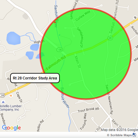
Looking for your valuable input on the study, design and planning process to improve the safety and traffic flow along this congested and unsafe stretch of State Road, Route 28. Cape Cod Commission Project Page
Update: 3/2/2022
View Final Route 28 at Santuit-Newtown Road Safety Audit HERE
JUST INFORMED THIS IS NOT A PUBLIC MEETING!
Virtual Road Safety Audit (RSA) on Thursday, December 9, 2021 from 1:00 PM to 4:00 PM for the intersection of Route 28 at Santuit-Newtown Road.
UPDATE: 11/23/21
Road Safety Audit Review Prompt List
The Safety Review Prompt List provides basic safety-related questions to use when evaluating a given roadway location. The prompt list should be considered when evaluating a roadway to design improve- ments or conduct a Road Safety Audit. The primary purpose of the prompt list is to identify potential road safety hazards. The list is meant to be general and should be used to prompt an evaluator as to specific matters identified in the field that may have an adverse effect on road safety. The Safety Review Prompt List is not a check of compliance with design standards.
This Prompt List represents the minimum that should be considered when exploring safety opportunities and is not intended to address all aspects of safety.
A summary of the responses should be prepared to highlight potential safety improvement opportunities.
Speed
Are posted speed limits consistent with speed regulations; are they adequate?
Are design features consistent with the posted speed (passing opportunities, sight distance,
warning signs for horizontal and vertical curves, clearance intervals, sign placement, etc.) Are adequate controls in place for driver compliance with speed limits?
Multi-modal
Have accommodations been provided for safe movement of pedestrians, bicycles, emergency vehicles, public transportation, and commercial vehicles?
What design features could be improved, added, or removed to enhance the safe mobility of the various modes?
Pavement Markings
Are there highly visible and retro reflective edge lines, center lines, and other pavement markings?
Do the pavement markings provide sufficient guidance to the road users? Can the placement of the pavement markings be modified to improve guidance to road users?
Signs
Are all signs retro reflective and visible for all roadway conditions, including placed free from obstructions?
Are signs located to maximize perception and reaction while minimizing intrusion in clear zones? Does the signage provide adequate guidance to road users for given road conditions?
Are pavement markings and signs consistent in effectively guiding road users?
Intersection Control
Do all signs (stop signs, lane assignments, street names, etc.) provide visible, clear, non-conflicting messages?
Is there clear, non-conflicting visibility of traffic control (signal heads, signs, and markings) from all approach lanes?
Has the potential of misrepresentation of intersection control been considered (at closely spaced intersections or through control that is against expectation)?
For signalized intersections, have the implications on safety been considered for the signal phasing?
Is there a safe means by which all modes can travel through the intersection? Lighting
Is lighting (from headlights and/or streetlights) adequate for specific roadway conditions and/or use?
If glare exists from sunlight or opposing headlights, are there countermeasures that can be implemented to minimize potentially detrimental effects?
Obstructions
Are there obstructions to sight lines or roadway guidance (signs, markings, etc.) that can be removed, relocated, or minimized as part of this project?
If obstructions or fixed objects exist but cannot be moved, can they be shielded (with guardrails, etc.) or delineated (with reflectors) to improve road user safety? If so, what can be done?
Pavement
Could the condition of the pavement impact mobility and safety (potholes, edge drop-offs, skid resistance, etc.)?
What improvements can be made to minimize safety impacts?
Access Points and Traffic Generators
Is the access control sufficient for the road’s function?
Are site access points located to maximize safety while still providing adequate access?
Have impacts of site developments been adequately accommodated for safe mobility of all
road users?
Parking
Is parking clearly delineated and in conformance with signs, markings, and regulations? Might parking obstruct mobility/safety of pedestrians and other roadway users?
Weather Conditions
Have accommodations been made for impacts from adverse weather condition (storage of snow, removal of ponding, adequate drainage, signage of low salt areas, maintenance program for snow removal, and catch basin clearing, etc.)?
Auxiliary Lanes
Could taper locations and/or alignments contribute to safety challenges?
Could lack of climbing lanes or passing zones cause driver frustration?
Do acceleration/deceleration lane lengths necessitate additional signage and/or markings?
Animals
Do animal migrations impact safety?
Can measures be taken to reduce animal-vehicle conflicts
The Cape Cod Commission (CCC), in coordination with MassDOT and the Town of Barnstable, have scheduled a Virtual Road Safety Audit (RSA) on Thursday, December 9, 2021 from 1:00 PM to 4:00 PM for the intersection of Route 28 at Santuit-Newtown Road. Your involvement (or a representative from your agency/department) in the RSA is important and will result in specific recommendations for improved safety at this intersection in the village of Cotuit in the Town of Barnstable.
Please find a copy of the agenda and meeting materials RSA Agenda – Rt 28 at Santuit Newtown Rd Dec_2021 Crash Diagram_Santuit_Newtown_Final SantuitNewtown Crash Data Spreadsheet Cotuit_Route_28_Corridor_Study_Final_Report-February_2017(web_version) Please review the crash data, crash diagram and prompt list ahead of time to become familiar with the crash issues and trends. We also encourage you to visit the intersections ahead of the meeting (in person or via Google Street View) if you are not already familiar with the roadway conditions. Additionally, please review the attached Route 28 Cotuit Corridor Study, dated February 2017, which was previously prepared by the Cape Cod Commission Transportation Staff and includes recommendations for this intersection.
Participants in the RSA will discuss crash experience and potential countermeasures for improving safety. Following the meeting, a draft and final report will be prepared by the CCC and distributed to the attendees for review and comment. The final report will guide the Town of Barnstable and MassDOT for potential future short- and long-term safety improvements for this intersection.
The meeting will be held virtually on the Zoom platform. Participants may also dial into the meeting on their phone. See Zoom login details below.
Zoom Meeting Link – https://capecodcommission.org/transportation/join
June 2016
The Cape Cod Commission and the Town of Barnstable will be holding a Public Meeting on the Route 28 corridor from Route 130 to Santuit/Newtown Road.
Looking for your valuable input on the study, design and planning process to improve the safety and traffic flow along this congested and unsafe stretch of State Road, Route 28. Cape Cod Commission Project Page


The Barnstable Police Department has recently received another report of patrons at a local bar feeling the effects of possible “date rape drugs”. Although there have been no assaults reported at this time, members of the Barnstable Police Department have been actively investigating these incidents. As a result of the ongoing investigation, information has been developed that the method of ingestion of these drugs may not just be drinks, it is possible that the substance is being delivered via altered “vape” cartridges. Based on this new information the Department is urging individuals that are gathering in social settings to not only keep a close watch on their beverages, but to also avoid sharing or using “vape” cartridges from unknown people.
If you have any information regarding individuals or establishments selling or distributing altered “vape” cartridges please contact Detective Andrew Johnson at johnsona@barnstablepolice.com, Detective Spencer Jackson at jacksons@barnstablepolice.com, or the Barnstable Police Detective Unit at 508-778-3820.


You must be logged in to post a comment.