Remains in Effect until January 30, 1 pm
View Weather Forecast Here

Remains in Effect until January 30, 1 pm
View Weather Forecast Here
Weather Forecast Here
DPW STORM UPDATE!
January 4, 2018 10:30 PM – The bulk of the snow has ended. We have begun final salting of the main roads. Once that has been completed we will begin salting secondary roads. We expect that to be completed at approximately 4:00 AM. Temperatures are dropping, so walks and areas that do not have salt on them will be slick. If you go out, please be cautious.
January 4, 2018 7:30 PM – We still are experiencing bands of snow coming through, and as a result are continuing to scrape and salt the main roads. Secondary road plow drivers are on their routes as well. Once the snow stops falling, crews will finish scraping and apply an application of salt on all roads (mains and secondary roads), and parking lots. Please be aware, temperatures have dropped below freezing and with all of the moisture we received there is a lot of ice on walks and roads. If you must go out, please proceed with caution.
January 4, 2018 2:00 PM – The rain has started to turn to snow. Western portions of the Town are reporting heavy slush on the roads, and the eastern portions are starting to shush up as well. We are dispatching the main road plows and spreaders to start to scrape off the slush and get a layer of salt down. Secondary road contractors have been called in, and should be on their routes in an hour or so. We have also experienced flooding in coastal areas on the north side of town due to the high tides and wind pushing water on shore. If you must travel, please be aware that as temperatures continue to drop all of the moisture on the roads will freeze and driving will become hazardous.
January 4, 2018 08:15 AM – Good morning, our first large storm of the season is at our doorstep. “Grayson”, as named, is predicted to bring us rain through mid-day, then transition to a mix, and finally become just snow. Depending on the forecast you listen to, snow totals are predicted from less than an inch to up to 4-8 inches. As a result, the DPW is preparing for the higher amounts, and will adjust if get the lesser totals. Spreaders are on site standing by to address icing, and main road plows will be on station starting at 10AM in the event of an early turn-over. Tree crews are also ready in the event that the predicted winds cause tree damage. Finally we are monitoring for possible flooding due to rain falling on frozen ground, and the timing of high tides. At this point we just need to wait to see what Mother Nature send us. All forecasts are predicting that driving conditions this afternoon will be poor, so please stay in if possible.
As a reminder, the Transfer Station will be closing at noon, or sooner if the winds intensify faster than predicted.
Track Snow Fleet HERE
URGENT - WINTER WEATHER MESSAGE
National Weather Service Taunton MA
1022 PM EST Wed Jan 3 2018

MAZ022-023-041130-
/O.CON.KBOX.WS.W.0001.180104T1500Z-180105T0600Z/
Barnstable MA-Dukes MA-
Including the cities of Chatham, Falmouth, Provincetown,
and Vineyard Haven
1022 PM EST Wed Jan 3 2018

...WINTER STORM WARNING REMAINS IN EFFECT FROM 10 AM THURSDAY TO
1 AM EST FRIDAY...

* WHAT...Heavy snow expected. Plan on difficult travel conditions.
  Expect damage to trees and power lines as well. Total snow
  accumulations of 2 to 6 inches are expected.

* WHERE...Cape Cod and Marthas Vineyard.

* WHEN...From 10 AM Thursday to 1 AM EST Friday.

* ADDITIONAL DETAILS...High Wind Warning is also in effect for
  gusts as high as 60 to 70 mph. There should be an hour or two
  where whiteout conditions occur. Be prepared for significant
  reductions in visibility at times.

PRECAUTIONARY/PREPAREDNESS ACTIONS...

A Winter Storm Warning for snow means severe winter weather
conditions are expected. If you must travel, keep an extra
flashlight, food and water in your vehicle in case of an
emergency. The latest road conditions for the state you are
calling from can be obtained by calling 5 1 1.
VIEW FORECAST HERE

…WINTER WEATHER ADVISORY IN EFFECT FROM NOON SATURDAY TO 1 AM
EST SUNDAY…
* WHAT…Snow expected. Plan on slippery road conditions. Total
snow accumulations of 2 to 4 inches are expected.
* WHERE…Barnstable MA County.
* WHEN…From noon Saturday to 1 AM EST Sunday.
* ADDITIONAL DETAILS…Be prepared for reduced visibilities at
times.
PRECAUTIONARY/PREPAREDNESS ACTIONS…
A Winter Weather Advisory for snow means periods of snow will
cause primarily travel difficulties. Be prepared for snow covered
roads and limited visibilities, and use caution while driving.
The latest road conditions for the state you are calling from can
be obtained by calling 5 1 1. Weather HERE

Reported Weather Related Cancellations & Closures, Barnstable:

Cotuit Main Street is detoured from Screecham Way to Lowell Road due to a tree in the road.
Cape Cod Community College is CLOSED TODAY!
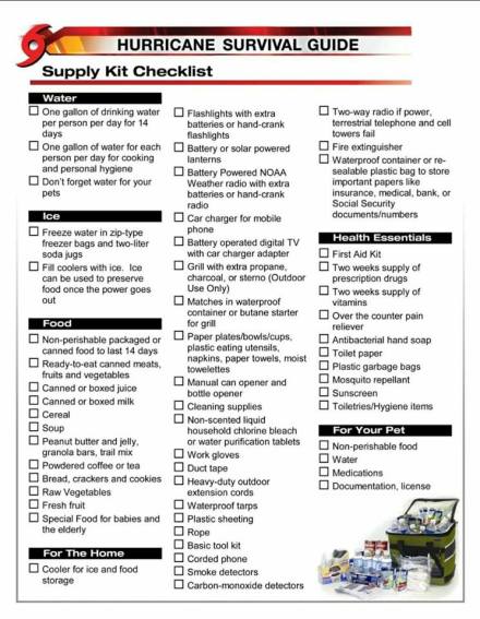 Don’t forget your Pets!


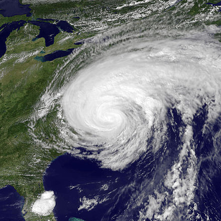
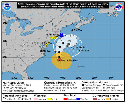
Update: September 18, 2017…TROPICAL STORM WARNING IN EFFECT..
* WIND
– LATEST LOCAL FORECAST: Below tropical storm force wind
– Peak Wind Forecast: 20-30 mph with gusts to 60 mph* STORM SURGE
– LATEST LOCAL FORECAST: Localized storm surge possible
– Peak Storm Surge Inundation: The potential for 1-3 feet
above ground somewhere within surge prone areas
– Window of concern: Begins early this afternoon– POTENTIAL IMPACTS: Limited
– Localized inundation with storm surge flooding mainly along immediate shorelines and in low-lying spots, or in areas farther inland near where higher surge waters move ashore.
– Sections of near-shore roads and parking lots become
overspread with surge water. Driving conditions dangerous
in places where surge water covers the road.
– Moderate beach erosion. Heavy surf also breaching dunes, mainly in usually vulnerable locations. Strong rip currents.
– Minor to locally moderate damage to marinas, docks,
boardwalks, and piers. A few small craft broken away from
moorings.* FLOODING RAIN
– LATEST LOCAL FORECAST:
– Peak Rainfall Amounts: 4-8 inches, with locally higher
amounts.– POTENTIAL IMPACTS: Limited
– Localized rainfall flooding may prompt a few evacuations.
– Rivers and tributaries may quickly rise with swifter
currents. Small streams, creeks, canals, arroyos, and
ditches may become swollen and overflow in spots.
– Flood waters can enter a few structures, especially in
usually vulnerable spots. A few places where rapid ponding
of water occurs at underpasses, low-lying spots, and poor
drainage areas. Several storm drains and retention ponds
become near-full and begin to overflow. Some brief road and bridge closures.* FOR MORE INFORMATION:
– http://weather.gov/boxAttention Town of Barnstable Mooring Permit Holders!
Please be advised of a potential strong wind/rain event next week 9/18/17.HERE is the link to the storm precautions web page. Please take all necessary precautions and if you have any questions contact the Harbormasters Office at 508-790-6273


You must be logged in to post a comment.