03-17-22 Agenda
Submit Comments on Agenda Item HERE
View Meeting Live on Channel 18 HERE
03-17-22 Minutes
03-17-22 Video

Winter Storm Watch
for Barnstable County
Issued by National Weather Service
Boston, MA
2:54 AM EST Thu, Feb 24, 2022
…WINTER STORM WATCH REMAINS IN EFFECT FROM LATE TONIGHT THROUGH FRIDAY EVENING…
* WHAT…Heavy snow possible. Total snow accumulations of 3 to 6 inches possible. Winds could gust as high as 35 mph.
* WHERE…The south coasts of both Rhode Island and Massachusetts including Cape Cod.
* WHEN…From late tonight through Friday evening.
* IMPACTS…Travel will be be very difficult especially for the Friday morning commute. A flash freeze is possible later Friday afternoon and early evening.
* ADDITIONAL DETAILS…Snow will overspread the region between 1 and 3 am Friday morning. The snow will quickly become heavy, but change to sleet and rain by early to mid morning on Friday. Precipitation may change back to a period of snow later Friday afternoon and early evening along with a potential flash freeze.
PRECAUTIONARY/PREPAREDNESS ACTIONS…
Monitor the latest forecasts for updates on this situation.
VIEW FORECAST HERE

(3) Emergency Shelters are Open
All citizens seeking shelter at one of the open regional shelters, please exercise extreme caution while road conditions remain hazardous. Members of the public are advised to shelter in place, if able, until the wind and snow ease in the late afternoon/evening.
Shelters are staffed by 24 AmeriCorps Cape Cod Members, Members of Regional CERT Teams, and the Cape Cod Medical Reserve Corps. All three locations have emergency food available, provided by the Salvation Army.
The remaining shelters at Dennis-Yarmouth High School, Cape Cod Regional Technical High School, and Nantucket High School are on standby. Check OPEN/CLOSED status of shelters at https://www.bcrepc.org/
The BCREPC wants to emphasize that during shelter operation, COVID-19 remains a significant concern. Residents and visitors should reach out to family and friends first and access shelters only when other options are not available. Likewise, the public is asked to check on neighbors, relatives, and friends who may need assistance.
Masks are required at emergency shelters. People are encouraged to bring their own, but masks will also be available for anyone who needs them.
The Tribal Headquarters in Mashpee will be open for Mashpee Wampanoag Tribe Members to shelter.
Anyone who must utilize a shelter should bring at least three days of essentials, including all medications.
Shelters can accommodate people who use an oxygen breathing apparatus.
Those bringing infants or toddlers to the shelters should also bring formula, food, diapers, wipes, changes of clothing, toys, and a “pack ‘n play” or portable crib and bedding.
Pets are accepted at all regional shelters. Please bring all your pet supplies to the shelter except for crates, which are provided by the shelter. You cannot sleep with your pet(s).
PUBLIC URGED TO STAY INDOORS AND STAY OFF ROADS
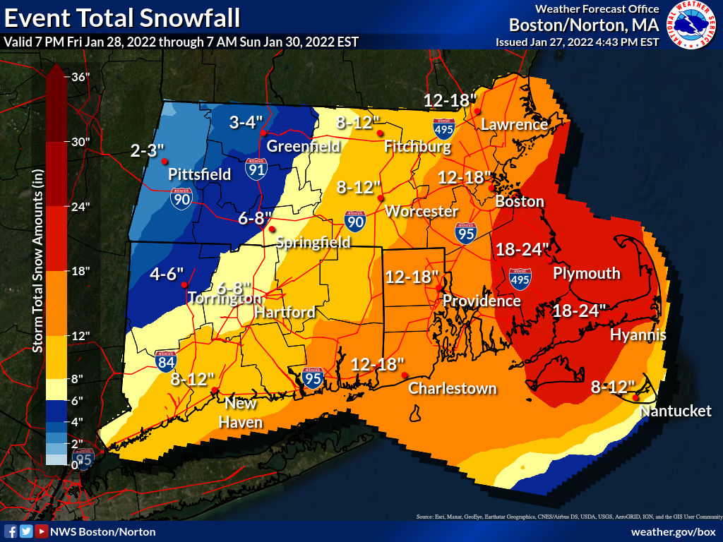
URGENT - WINTER WEATHER MESSAGE
National Weather Service Boston/Norton MA
320 PM EST Thu Jan 27 2022

MAZ017>023-280430-
/O.CON.KBOX.WS.A.0005.220129T0500Z-220130T0500Z/
Northern Bristol MA-Western Plymouth MA-Eastern Plymouth MA-
Southern Bristol MA-Southern Plymouth MA-Barnstable MA-Dukes MA-
Including the cities of Taunton, Brockton, Plymouth, Fall River,
New Bedford, Mattapoisett, Chatham, Falmouth, Provincetown,
and Vineyard Haven
320 PM EST Thu Jan 27 2022

...WINTER STORM WATCH REMAINS IN EFFECT FROM LATE FRIDAY NIGHT
THROUGH SATURDAY EVENING...

* WHAT...Heavy snow possible. Total snow accumulations of 15 to
  22 inches possible. Winds could gust as high as 65 mph.

* WHERE...Portions of southeastern Massachusetts.

* WHEN...From late Friday night through Saturday evening.

* IMPACTS...Travel could be very difficult to impossible. Strong
  winds could cause tree damage.
VIEW FORECAST HERE
Monday January 24, 2022 9 am – 2:30 pm
Cotuit Federated Church, 40 School St., Cotuit
Check and request timed appointment HERE
Thank you!


You must be logged in to post a comment.