
UPDATE: View Results HERE


Sunday September 24, 9am-noon Barnstable Sandy Neck Beach Park
Contact Donna Bragg 508-362-8300
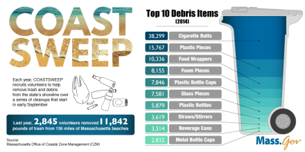
View Cape Cod Towns participating HERE

Cotuit Fire Commissioner’s Meeting
Union Negotiating Committee
Monday September 18, 5:30pm, Freedom Hall
View Agenda HERE
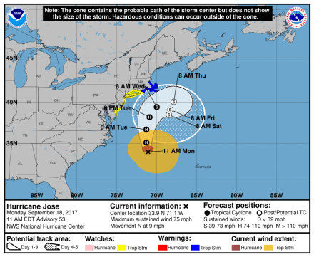
Update: September 18, 2017…TROPICAL STORM WARNING IN EFFECT..
* WIND
– LATEST LOCAL FORECAST: Below tropical storm force wind
– Peak Wind Forecast: 20-30 mph with gusts to 60 mph* STORM SURGE
– LATEST LOCAL FORECAST: Localized storm surge possible
– Peak Storm Surge Inundation: The potential for 1-3 feet
above ground somewhere within surge prone areas
– Window of concern: Begins early this afternoon– POTENTIAL IMPACTS: Limited
– Localized inundation with storm surge flooding mainly along immediate shorelines and in low-lying spots, or in areas farther inland near where higher surge waters move ashore.
– Sections of near-shore roads and parking lots become
overspread with surge water. Driving conditions dangerous
in places where surge water covers the road.
– Moderate beach erosion. Heavy surf also breaching dunes, mainly in usually vulnerable locations. Strong rip currents.
– Minor to locally moderate damage to marinas, docks,
boardwalks, and piers. A few small craft broken away from
moorings.* FLOODING RAIN
– LATEST LOCAL FORECAST:
– Peak Rainfall Amounts: 4-8 inches, with locally higher
amounts.– POTENTIAL IMPACTS: Limited
– Localized rainfall flooding may prompt a few evacuations.
– Rivers and tributaries may quickly rise with swifter
currents. Small streams, creeks, canals, arroyos, and
ditches may become swollen and overflow in spots.
– Flood waters can enter a few structures, especially in
usually vulnerable spots. A few places where rapid ponding
of water occurs at underpasses, low-lying spots, and poor
drainage areas. Several storm drains and retention ponds
become near-full and begin to overflow. Some brief road and bridge closures.* FOR MORE INFORMATION:
– http://weather.gov/boxAttention Town of Barnstable Mooring Permit Holders!
Please be advised of a potential strong wind/rain event next week 9/18/17.HERE is the link to the storm precautions web page. Please take all necessary precautions and if you have any questions contact the Harbormasters Office at 508-790-6273
Cotuit Fire Commissioner’s Meeting
Union Negotiating Committee
Thursday September 14, 4:30pm, Freedom Hall
View Agenda HERE

ROAD SURFACE MILLING & PAVING OSTERVILLE-W. BARNSTABLE ROAD
The Department of Public Works will be performing roadway improvements on Osterville – West Barnstable Road in Marstons Mills between Rt. 28 and Flint Street (near transfer Station) beginning on Monday, September 18, 2017. Improvements include milling of the existing roadway surface and installation of new asphalt pavement. Work is expected to be completed by Friday, September 22, 2017, weather permitting.
Vehicle access during construction operations will be restricted to one lane. Motorists are advised to seek alternate routes to avoid the construction work.
Operations will start promptly at 9 AM and run until 3 PM, after which time traffic will be opened back onto both lanes of the roadway.
CONTACT: JOE ORCIUCH Tel: 508-790-6400, Ext 4940

The Public Health Division is pleased to announce the following:

When: Every Wednesday morning from 9:30 a.m. until 11:00 a.m.
Where: Barnstable Senior Center (lower level), 825 Falmouth Rd, Hyannis, MA 02601
For:
– Health Information
– Vaccinations
– Blood Pressure Monitoring
If you should have any questions, please call the Town of Barnstable Public Health Division Office at (508) 862-4644


You must be logged in to post a comment.